Access Sites, Maps, & Guides
Grab your paddle and your quest for adventure and head to the Buckhannon and Tygart Valley Rivers! Together they form the 45 mile BTV Water Trail, with miles of adventure as the river flows through a forested landscape. Paddle, boat, fish, and explore interesting attractions, where history and culture coincide with nature’s scenic beauty.
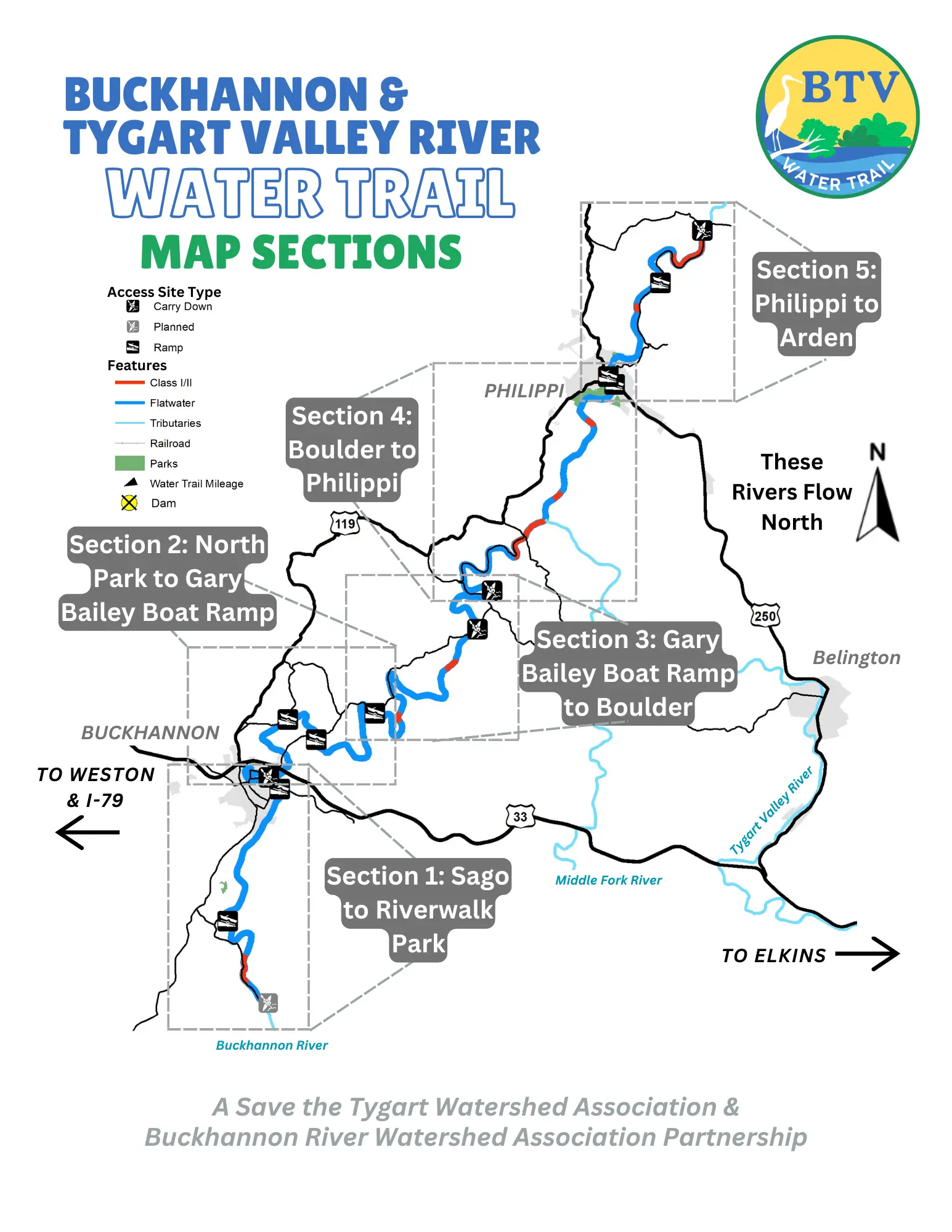
Access Sites
Sago
Currently there is no public access near Sago to designate the start of the Water Trail. Constructing a public access site will be a priority as the Water Trail is developed and improved.
Hampton Boat Ramp
Concrete ramp with large parking area. Also known as the Gerald Lee Scott Boat Ramp. GPS: 38.939065, -80.239031. Follow Rt. 20 south of Buckhannon for approximately 4 miles, turn onto Sago Rd for 0.7 miles, turn left onto Co Rt 22/1 for 0.2 miles, then turn right onto Ivanhoe Road. Continue 0.3 miles down to the access sites near Hampton bridge
Riverwalk Park Boat Ramp
Concrete ramp with parking adjacent to the walking path. Picnic tables and seasonal restrooms available near the baseball fields. GPS: 38.991151, -80.212178.
Directions: Follow Rt 20 south through Buckhannon, turn onto Marion St, then turn left onto Camden St and continue 0.7 miles to Buckhannon Riverwalk Park. Follow the brown public stream access signs.
North Buckhannon Park
Grass carry down access to the river with parking, playground, pavilions, picnic tables, and seasonal restrooms. GPS: 38.996188, -80.217357 Directions: Approximately 1.7 miles east of Buckhannon on US-48, turn south onto 5th St., then turn left onto Cleveland Ave to the park.
Pringle Tree Park
Grass carry down access to the river with parking, playground, pavilions, historical points of interest, and seasonal restrooms. GPS: 39.018705, -80.207663 Directions: Approximately 1 mile north of Buckhannon on Rt 20/119, turn onto Pringle Tree Park road and continue for 1.5 to the park.
River Road Boat Ramp
Concrete boat ramp with small parking area on River Road north of Buckhannon. No facilities at this location. GPS: 39.010624, -80.193247 Directions: Just south of the Rt. 20 and US-48 interchange, follow Morton Ave east and continue along Post Mill Rd for approximately 3 miles. Turn onto River Rd and continue 0.1 mile to the access site.
Hall Road Boat Ramp
Concrete boat ramp with large parking area and picnic table. No restroom facilities. Also known as the Gary Bailey Boat Ramp. GPS: 39.020832, -80.163518. Directions: Just south of the Rt. 20 and US 33/48 interchange, follow Morton Ave east and continue along Post Mill/Hall Rd for approximately 4.5 miles.
Hall Bridge
Currently there is no public access to the river at the Hall Bridge. Please respect private property. Developing river access in this area is a priority for development.
Boulder
Grass carry down access next to the Boulder Bridge with a small pull off area for parking. Please respect private property and stay within the 15 foot right-of-way next to the bridge. No facilities available. Only experienced paddlers should enter the river here and paddle to Philippi. This section contains difficult rapids. GPS: 39.068793, -80.103374 Directions: From Rt 119 near Volga, follow Audra Park Road for 2.5 miles. Access site is on river right on the downstream side of the bridge.
Philippi Dam Pool Boat Ramp
Concrete boat ramp upstream of the Philippi dam with parking. No facilities available. GPS: 39.149779, -80.04008 Directions: Near the Philippi Covered bridge at the Blue & Grey park, follow the gravel road at the southern end of the parking lot to the parking area. Philippi Covered Bridge Boat Ramp Concrete ramp underneath the historic Philippi Covered Bridge with a large parking area and a picnic table. GPS: 39.152849, -80.04353 Directions: Located under the Philippi Covered bridge, park at the Blue and Grey park off 119
Arden Grade Road Boat Ramp
Concrete ramp with small parking area off Arden Grade Road. GPS: 39.189778, -80.016254 Directions: From Main St. in Philippi, turn onto Pike and continue onto Meridan Rd for 1.5 miles, then turn left onto Chestnut Ridge Rd and immediately veer left onto Arden Grade Road. The access site is approximately 2 miles.
Arden Bridge
Currently no public access near Arden to designate the end of the Water Trail. Constructing a public access site will be a priority as the Water Trail is developed and improved. Downstream of the Arden Bridge, the river flows through extreme whitewater.
Section 1: Sago to Buckhannon Riverwalk Park
The Water Trail starts near Sago and flows through a short segment of Class I riffles downstream of the Sago bridge. The river then enters a scenic gorge where the flow significantly decreases. The river approaches Hampton and flows beneath a beautiful single lane bridge. Downstream of Hampton, excellent beginner and family friendly flatwater continue for 4.5 miles to Buckhannon Riverwalk Park. All paddlers are advised to exit the river at the Riverwalk Park. A low-head dam is located ½ mile downstream of the park. This section has two existing access sites, Hampton and Riverwalk Park, both concrete ramps. We are planning to construct an additional access site upstream of Sago in the future.
Length: 7.5 miles
Class: Flatwater
Level: Beginner friendly
Section 2: North Buckhannon Park to Hall Road
Downstream of North Buckhannon Park the river flows through beautiful rural scenery, alternating between mature forest and pasture. This section offers excellent scenic and wildlife viewing opportunities as paddlers leave the city of Buckhannon. The river passes under the U.S. Route 33 bridge and under the Post Mill Road bridge. In this section, the river is mostly slow and shallow, with some deep pools and very short segments of flowing rifles. Pringle Tree Park appears on river left after 3.75 miles from North Buckhannon Park.
The river lazily flows past Pringle Tree Park and passes under Post Mill Road for a second time, along with two other small railroad bridges. The River Road Public Access site appears on river right 1.25 miles after Pringle Tree Park. Downstream, the river continues through long, deep pools interspersed with short rifles for 4 miles to Hall Road South Access Site. In this section, the river regains its natural flow characteristics as large in-stream boulders become visible.
Section Length: 9 miles
Class: Flatwater & Class I
Level: Beginner friendly
Section 3: Hall Road to Boulder (9.5 miles)
After the Hall Road Access Site, the river meanders for 7 miles to the access site at Hall. This section is remote and is one of the longest distances between access sites along the Water Trail. The river flows through numerous meanders and passes through an especially scenic forest gorge. Sand Run, a tributary, enters on river right, and then the river passes through the Wentz Ford community. After passing through this small residential area, the river gradient increases slightly as the slow pools are replaced with Class I riffles and rock gardens before passing under Hall Road. After Hall Road, the river resumes its leisurely character for 2.5 miles to Audra Park Road Bridge at Boulder. Just upstream of Boulder, a small Class I riffle and rock garden segment appear.
Section Length: 9.5 miles
Class: Class I
Level: Beginner friendly
Section 4: Boulder to Philippi (10.8)
Downstream of Boulder, the Buckhannon River slowly flows through quiet meanders. Approximately 4 miles downstream of Boulder, the river gradient increases. This section is the most difficult and remote section of the Water Trail and contains Class I and Class II rapids. Only experienced paddlers are advised to paddle this section. This section provides excellent scenic and wildlife viewing opportunities, as well as historical points of interest (two covered bridges). As the river flows through Carrolton, Class I/II rapids continue ¾ mile to the Buckhannon and Tygart River confluence. Downstream of the confluence, the gradient decreases and alternatures through shallow runs and deep pools. Here, the river flows through the tailend of the remote Tygart Gorge. As the river appears in Philippi, a low-head dam appears just upstream of the Philippi Covered Bridge.
Section Length: 10.8 miles
Class: Class I/II
Level: Experienced paddlers only
Section 5: Philippi to Arden
Downstream of Philippi, the river flows through a scenic and flatwater 3 mile stretch. Then, the river gradient increases and a 1 mile section of Class I/Class II rapids exist upstream of Arden. This more difficult section can be avoided by taking out at the Felton Road access site. The Water Trail ends at Arden. Downstream of the Arden bridge, the Tygart River continues a tumultuous journey through extreme whitewater.
Section Length: 7.2 miles
Class: Flatwater and Class I/II
Level: First 3 miles beginner friendly, last 4 miles experienced paddlers only